 |
|
|
Land Patent Records Land Records Tutorial Land Records Terminology Land Patentees (by Township/Range) Land Patentees - (Township/Range Index) Township 44N Township 45N Township 46N Township 47N Township 48N Township 49N Land Patentees Alphabetical by Surname 'A' Surnames 'B' Surnames 'C' Surnames 'D' Surnames 'E' Surnames 'F' Surnames 'G' Surnames 'H' Surnames 'I' Surnames 'J' Surnames 'K' Surnames 'L' Surnames 'M' Surnames 'N' Surnames 'O' Surnames 'P' Surnames 'Q' Surnames 'R' Surnames 'S' Surnames 'T' Surnames 'U' Surnames 'V' Surnames 'W' Surnames 'X' Surnames 'Y' Surnames 'Z' Surnames 1876 Land Owners 1897 Land Owners 1919 Land Owners 1876 Callaway Plat Maps 1897 Callaway Plat Maps |
1830 Plat Maps for
|
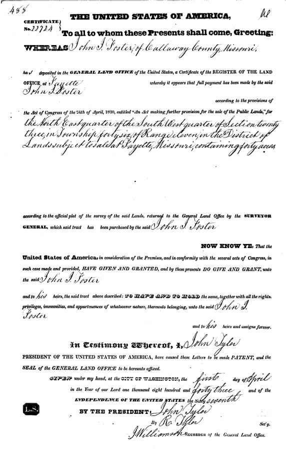
Sample apprearance copy of original patent image [readable and downloadable] available from BLM website. Search by Name, Township/Range, or Accession Number.
 |
In the Southern United States in the State-Land states, land is surveyed in the indescriminate metes and bounds system, not the federal township-range system. The metes and bounds survey system uses natural land features, such as trees and streams, as well as neighboring land owners, along with distances to describe plots of land.
For further discussion of Land Records in the United States, see Land and Tax Records by William Thorndale in The Source: A Guidebook of American Genealogy (1984) edited by Arlene Eakle and Johni Cerny, Ancestry, Inc., Salt Lake City, UT.
The Township-Range System is also described in most of the recent Plat Books of the counties in the Public Domain states, as well as many basic geology text books, such as Laboratory Manual for Physical Geology (1983) Sixth Edition, by Zumberge and Rutford, W.H. Brown Co., Dubuque, Iowa.
Section
Basic unit of the system, a square tract of line one mile by one mile containing 640 acres.
Township
36 sections ar ranged in a 6 by 6 array, measuring 6 miles by 6 miles. Sections are numbered beginning with the northeast-most section, proceeding west to 6, then south along the west edge of the township and to the east.
Range
Assigned to a township by measuring east or west of a Principal Meridian
Range Lines
North to south lines which mark township boundaries
Township Lines
East to west lines which mark township boundaries
Principal Meridian
Reference or beginning point for measuring east or west ranges.
Base line
Reference or beginning point for measuring north or south townships.
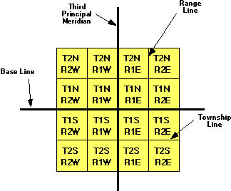
The largest grouping is the township which is named in reference to a Principal Meridian (P.M.) and a Baseline. T2N, R1E refers to Township 2 North (of the Baseline), Range 1 East (of the Principal Meridian).
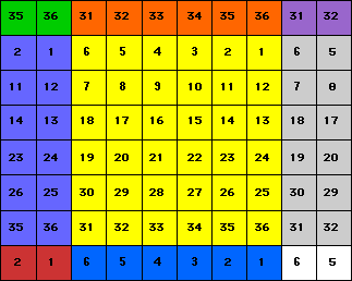
Within each township are 36 sections, each one mile square. Each section contains 640 acres. The sections are numbered from 1 to 36 in the following order. [Text only display]
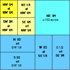
Within each section, the land is refered to as half and quarter sections. A one-sixteenth division is called a quarter of a quarter, as in the NW1/4 of the NW1/4. The descriptions are read from the smallest division to the largest.
A specific township is identified as being north or south of a particular baseline and east or west of a particular principal meridian. For example, T3N, R1E of the 3rd Principle Meridian is the third township north of the baseline in the first range east of the Third Principle Meridian. This particular 36 square-mile area is located in southern Illinois.
The land description generally starts with the smallest part of the description and proceeds to the largest definition. For example, SE1/4 of NW1/4 of Section 3, T3N, R1E, 3rd PM would be the southeast quarter of the northwest quarter of section 3 in township 3 north, range 2 east of the 3rd Principle Meridian.
You may find some irregularly shaped townships and sections which result from surveying errors and other difficulties.